 Workshop
 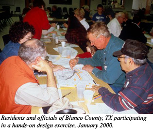 Workshop
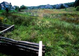
 This workshop describes and illustrates practical, proven techniques for protecting community-wide open space networks through "conservation design" principles in updated zoning and subdivision ordinances, in a density-neutral manner consistent with underlying zoning. For example, Virginia’s Hanover County has conserved more than 5,000 acres in this manner, at no public cost, and without negative impacts on landowners.
This is a technique that is easy to use, and is particularly useful when economic limitations or political considerations preclude the wide-spread implementation of PDR programs to purchase development rights (which are very costly), or TDR programs to transfer densities from rural areas to serviced locations (which are politically challenging). The same holds true for the adoption of Urban Growth Boundaries.
This workshop session, with its optional Hands-on Design Exercise, helps developers and local officials work together to accomplish complementary goals: the construction of full-density residential subdivisions (developers' goal) in a way that helps build a community-wide network of permanent conservation land in a healthful, attractive manner (officials' goal).
The session is geared toward experienced members of planning boards and commissions and to professional planners who write codes and review site plans. Model zoning and subdivision ordinance language is provided to program participants, upon request.
The session draws on numerous examples, ranging from those built at lower rural densities using individual wells and septic systems, to those created at higher densities in serviced locations. Examples also span a wide spectrum of price points, from affordable to entry level to upscale.
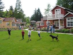
In areas served by public water and sewer, this program shows how conservation design techniques can be readily combined with TND principles to create walkable, mixed-use neighborhoods, often involving higher-density infill projects and situations involving incremental growth around the community's outer edges. This part of the program, sometimes called “The Greener Aspects of the New Urbanism”, is based largely on my fourth book (Crossroads, Hamlet, Village Town: Design Characteristics of Traditional Neighborhoods, Old and New), and shows how higher density neighborhoods can still be designed around, and incorporate, distinctive features of the natural and cultural landscape, producing more interesting results. Clients determine the degree of emphasis placed on rural versus New Urban (TND) examples.
|
|
The program describes a simple four-step design process for laying out this kind of greener neighborhood, devised over years of experience where such developments have been reviewed, approved, financed, built, sold and lived in throughout the USA and Canada. In addition to illustrating several case studies in which this process has been successfully followed, the program describes additional design enhancements that improve marketability and bottom-line profitability (through lot premiums and faster absorption). Developments of this nature are "twice green" achieving both environmental and economic goals.
Finally, the program describes how this design process can fit into the local regulatory framework, through specific provisions in comprehensive plans, zoning ordinances, and subdivision regulations. As each conservation subdivision is completed, another link in the community-wide network of open lands is expanded, until ultimately an interconnected network of conservation areas is preserved.
Workshop Length: This workshop usually runs two hours for the illustrated program, 60-75 minutes for the design exercise, plus 30 minutes for discussion.
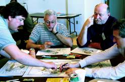
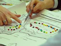
Hands-On Design Exercise: As a follow-up to thepowerpoint presentation, a participatory workshop (about 75 minutes long) is offered to provide attendees with an opportunity to learn first-hand how to design a neighborhood around the special features of any given property. Workshop participants have a chance to internalize what they have seen and heard during the powerpoint, by applying the four-step design process to a real parcel of land. Participants typically comment that this exercise makes the powerpoint more meaningful by helping them understand exactly how to implement the conservation design principles. This participatory workshop is where the learning curve rises steeply, and is especially recommended for those without much background in creative neighborhood design, such as local officials, engineers, surveyors (and even many land-use planners whose training was light on design).
|
 |
Bonus: Model ordinance language, in electronic form, will be provided free to participants, on request.
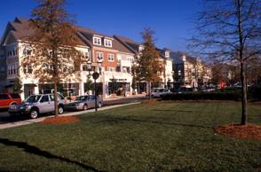
This program describes and illustrates various re-development design strategies to create mixed-use centers from existing highway strips, to help communities implement smarter, more sustainable development patterns, and includes ideas for improving downtown economic viability and attractiveness.
The material presented is largely drawn from my upcoming book, Envisioning Better Communities: Seeing More Options, Making Wiser Choices,publishedby Planners’ Press.
The 120-minute presentation (which can be adapted to fit time constraints) is generously illustrated with numerous successful examples and addresses the visual blight and land-use dysfunctionality of most highway commercial corridors and many downtowns. By adopting progressive site planning and design standards, cities and counties can prevent this kind of destructive development, which often spreads like a disfiguring disease along the regional road network.
Clients determine the degree of emphasis placed on reclaiming highway strips versus strengthening downtown centers, according to the needs of their audience.
This topic is of interest to professional planners, civic leaders, Planning Board/Commission members, landscape architects, engineers, commercial property owners and investors, and developers, who stand to benefit from the redevelopment and adaptive reuse of aging highway commercial corridors and downtowns into multi-use centers for the 21st century, as well as residents who care about the future economic vitality and livability of their community.
|
|
Multiple strategies blending the twin disciplines of Conservation Design and New Urbanism for rebuilding highway corridors, gradually increasing functionality and attractiveness.
Fundamentals of Form-Based Zoning (to locate different building types appropriately, according to scale and massing), and Low Impact Development strategies (to reduce the negative effects of new construction, particularly involving stormwater infiltration).
These concepts offer significant opportunities for commercial and mixed-use redevelopment, particularly in areas with existing infrastructure, increasing the viability of businesses, service providers, and current/future public transit operators.
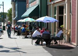
Insights into how downtowns can be made more economically viable and visually attractive, including examples of national chains and franchises that have adapted their designs to harmonize with community character and local building traditions rather than imposing standard corporate building models that homogenize community appearance produce results describable as “Anywhere, USA”.
Because the typical design life of most buildings is 25 to 30 years, communities can position themselves now to guide the future replacement of existing structures, by working to articulate a vision, adopt plans, enact appropriate codes, and provide other incentives to help ensure the future creation of economically viable and aesthetically attractive corridors and downtowns to meet the multiple needs and challenges of local residents and business owners.
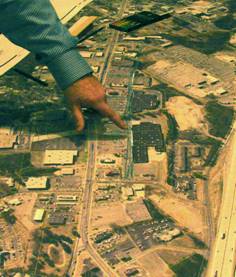
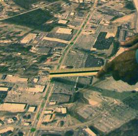
Hands-On Design Exercise: As a follow-up to thepowerpoint presentation, a participatory workshop (about 75 minutes long) is offered to provide attendees with an opportunity to learn first-hand how to retrofit an existing section of degraded commercial highway strip. Using an aerial photographic enlargement of a typical strip, participants mark up the base map with colored pencils to show how the kinds of improvements described and illustrated in the preceding presentation could be implemented in the typical example provided. When workshop participants have a chance to internalize what they have seen and heard during thepowerpoint, they gain a deeper understanding of the concepts involved, and always learn more.
|
|
Workshop Length: This workshop usually runs two hours for the illustrated program, 60-75 minutes for the design exercise, plus 30 minutes for discussion.
Bonus: Model ordinance language, in electronic form, will be provided free to participants, on request.